Gertrudis
Gold exploration in the Deseado Massif.
Overview and Location
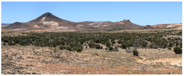
The Gertrudis Project is located in the northeastern part of the Deseado Massif, Argentina, approximately 100 km northwest of the Don Nicolas Mine and 150 km east of Cerro Negro (Figure 1). The Project is approximately 1.5 hours’ drive from Fitz Roy or Pico Truncado on good unpaved roads and farm tracks, and is situated at the western edge of a series of hills composed of mafic units of the Bajo Pobre Fm. (Figure 2). To the west of the mineralization, the mafic rocks give way to a plain occupied by Cretaceous post mineral volcaniclastics.
The Gertrudis Project property is an M.D. concession constituting 4,000 hectares and is comprised of two mineralized structures. The Gertrudis vein is the more prominent of the two and extends for 800 m. The David vein is exposed for 350 m.
The Project is available for Joint Venture.

Geology
The two veins on the Gertrudis Project are 300 m apart, sub-parallel and steeply dipping, and are comprised of silicified tectonic and volcanic breccias with argillic alteration halos. Low grade Au anomalies occur in both veins which are also associated with As, Sb and Hg anomalies.
The Gertrudis vein forms hilly and jagged topography. The northern and southern limits of this vein, at the surface, appear to be cut off by cross cutting northeast striking faults. This vein consists of silicified volcanic and tectonic breccias with an argillic alteration halo.
The smaller David Vein is parallel to the Gertrudis Vein and appears to be truncated at its southern limit by a northeast-striking fault. To the north, the David vein is covered by Tertiary basalt of the Bajo Grande Formation. To the east of the veins, the landscape is dominated by the mafic, hill forming units, of the Bajo Pobre which is generally unaltered with only calcite veins at the surface to the west of the veins is a plane of Cretaceous cover.
The Gertrudis and David Veins are north-northwest-striking structures and the surface gold mineralization is illustrated over a Magnetic Tilt Derivative image (Figure 3). The Gertrudis Vein dips steeply to the west-southwest and is well-exposed along most of its length. The Tilt Derivative image shows a combination of magnetic lows, some of which tend north-northwest, parallel and sub parallel to the veins, and another set that are circular to oblate in their orientation and appear to be related to a Tertiary basalt volcanic neck.
Average Au from the 86 samples on the Gertrudis Vein is 38 ppb. The Au is accompanied by averages of 75 ppb Hg, 145 ppb As, 53 ppm Pb and 3 ppm Sb. While the averages are low, the maximum values obtained from these elements are 320 ppb Au, 348 ppb Hg, 381 ppm As, 231 ppm Pb and 26 ppm Sb.
The David Vein is much less prominent and is 400 m in length with average Au from 20 samples of 23 ppb. The Au is accompanied by averages of 1,312 ppb Hg, 97 ppm As, 57 ppm Pb and 4.7 ppm Sb. The maximum values obtained from this vein are 99 ppb Au, 15,750 ppb Hg, 318 ppm As, 148 ppm Pb and 31 ppm Sb.
The Company interprets the Gertrudis Project represents the top of an epithermal system with potential for discovery of high-grade veins at depth. There is also potential for further mineralization on strike to the north and south, beneath the Tertiary and Cretaceous cover, as well as in parallel structures under the Cretaceous cover to the west.


Figure 3, Gertrudis M.D. with rock chip locations over regional geology.