+1 (905)-301-9983
Luna Roja
Primary Target
Low Sulphidation Gold and Silver disseminated in tuffs and also occurring in stockworks and veinlets in rhyolite domes.
Partner
Available for Joint Venture
Location
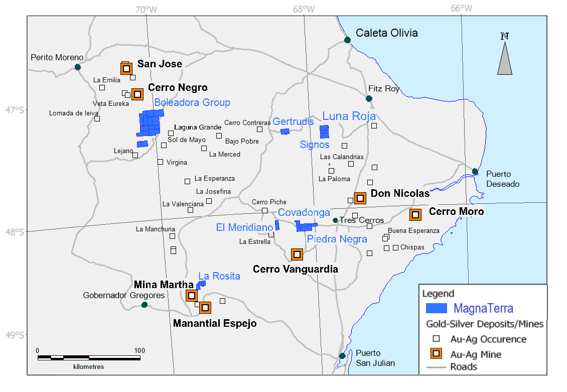
The Luna Roja Project is situated in the Santa Cruz Province of Argentina, on the Northern edge of the Deseado Massif (Figure 1) and is approximately 75 Km to the NW of the new Don Nicolas Mine and 30 km N-NW of the Las Calandrias Project (New Dimension Resources). The project is accessed from Fitzroy on 80 km of unpaved roads and farm tracks.
Project Operator
Magna Terra Minerals Inc.
Property Information
Magna Terra Minerals has 100% control of the El Monte I and El Monte II M.D. properties which constitute 6,000 Hectares on which the project is based.
Geology and Mineralization
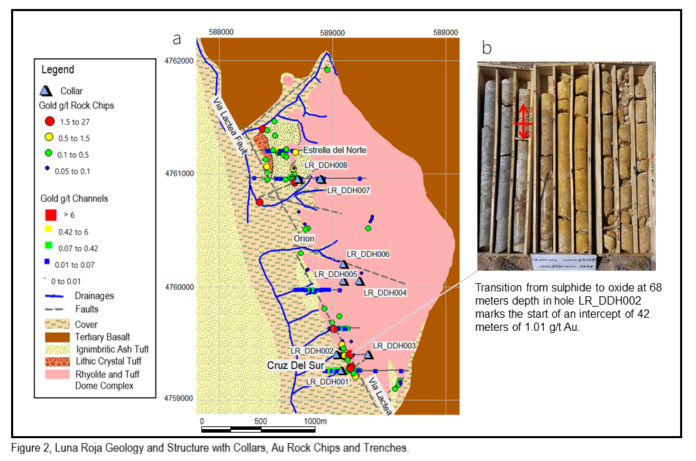
The Luna Roja project is centered on a 3 km long, N-NW striking fault, the Via Lactea Fault. The main lithologies are a package of felsic, lithic to lithic crystal tuffs and ash tuffs which are broken up by rhyolite domes. The tuffs are silicified in the vicinity of the fault and form a low rounded hill on the footwall side, whereas on the hanging wall side the tuffs are argillized and form a recessive area (Figure 2).
Trenching across the Via Lactea fault, adjacent to rhyolitic dome rocks and argillized tuffs, has revealed several zones of continuous mineralization at the surface. Assay results in the Cruz del Sur Zone include 55 meters of 0.41 ppm Au and 13.2 ppm Ag in Trench 2 and 35 meters of 0.10 ppm Au with 7.6 ppm Ag in trench 1. To the west of, and in the hanging wall of the Via Lactea fault, there are pervasively argillized and locally silicified tuffaceous rocks where hanging wall structures provide a favorable environment for disseminated and vein-style mineralization.
First phase drilling constituting 1184 meters of diamond core from 8 holes was completed between January 12th, 2019 and January 31st 2019, in a program designed to test three target areas – Cruz Del Sur, Orion and Estrella del Norte, (Figure 2).
All 8 holes were silicified throughout their lengths and a significant discovery was made in the Cruz del Sur Zone with holes LR_DDH001 and 2 which returned long disseminated intercepts. The Cruz del Sur discovery, which lies toward the southern end of the project, on the Via Lactea fault, is associated with Au in rock chips and trench channel samples on the southwestern edge of a major rhyolitic and tuffaceous dome complex, (see Figure 2 a).
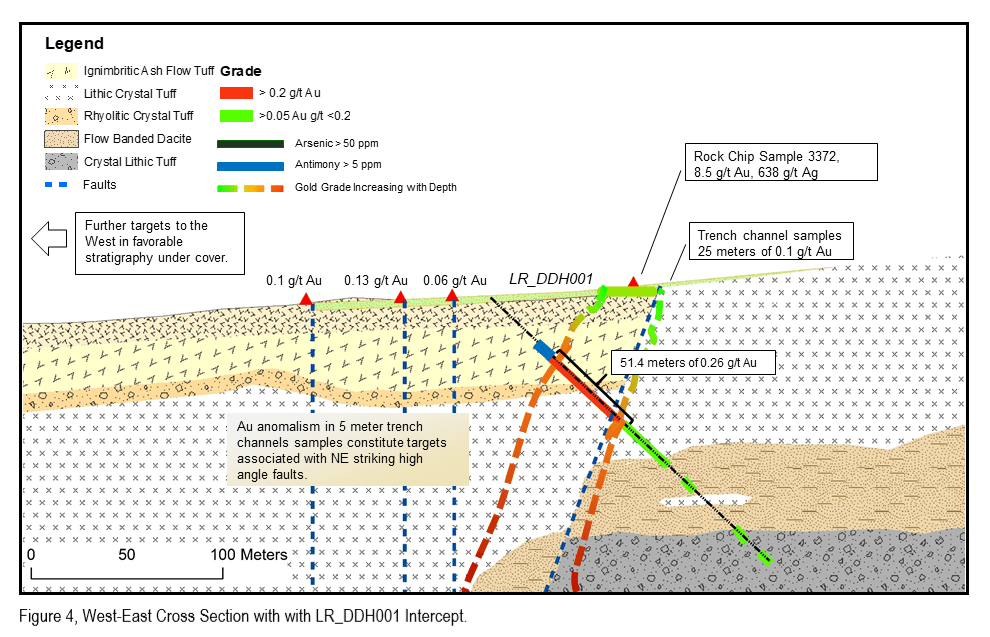
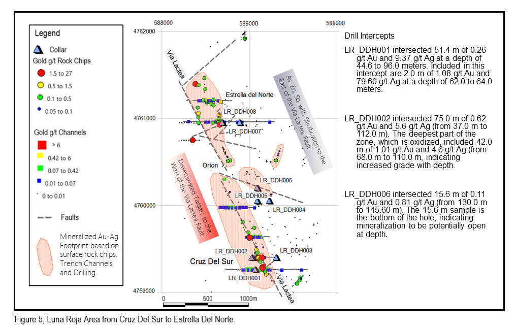
Drill hole LR_DDH001 intersected 51.4 m of 0.26 g/t Au and 9.37 g/t Ag at a depth of 44.6 to 96.0 meters, including, 2.0 m of 1.08 g/t Au and 79.60 g/t Ag at a depth of 62.0 to 64.0 meters.
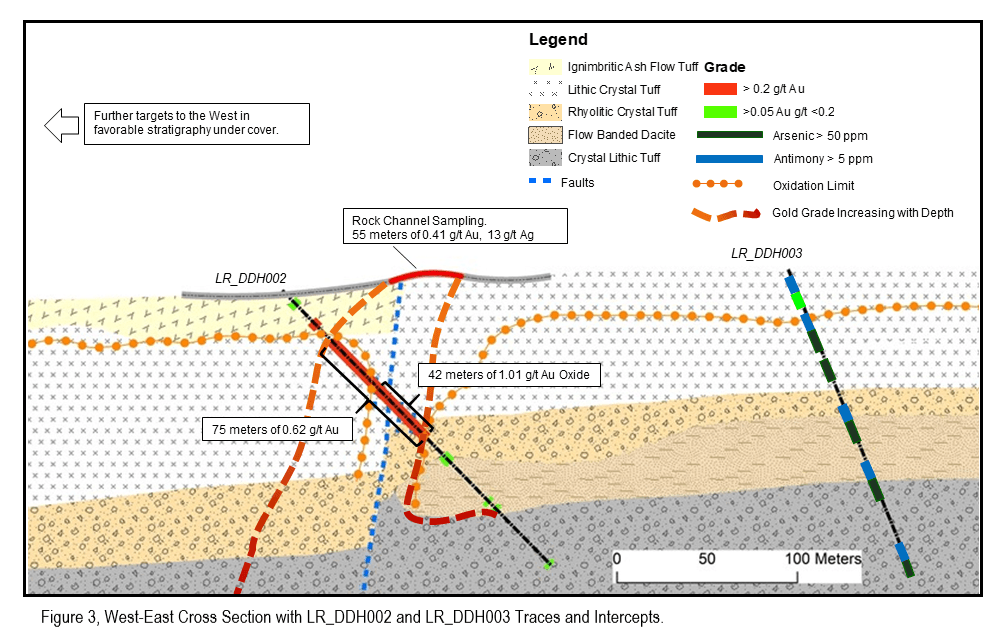
Drill hole LR_DDH002 intersected 75.0 m of 0.62 g/t Au and 5.6 g/t Ag (from 37.0 m to 112.0 m). The deepest part of the zone, which is oxidized (Figure 2 b), included 42.0 m of 1.01 g/t Au and 4.6 g/t Ag (from 68.0 m to 110.0 m), indicating increased grade with depth.
LR_DDH001 and LR_DDH002 target structurally controlled mineralization beneath wide Au anomalies in trenches 1 and 2. Figure 3 illustrates a West-East cross section, which includes LR_DDH002 and LR_DDH003. The Trench 2 intercept of 55 meters of 0.41 g/t Au and 13.2 g/t Ag occurs above the LR_DDH002 drill intercept and is structurally related to the oxidized zone of 1.01 g/t Au between 47 and 78 meters vertical depth. Mineralization appears to be controlled largely by the high permeability of the tuffaceous units to the West of the Via Lactea Fault, implying that the system is open to the West.
Trench 1 reported 25 meters of 0.1 g/t Au and 7.6 g/t Ag which occurs above the LR_DDH001 intercept and is structurally related to the mineralized zone with 0.26 g/t Au and 9.7 g/t Ag between 30 and 70 meters vertical depth, (see Figure 4). Additionally, Trench 1 reported three zones of anomalous Gold comprising 5 meters of 0.1 g/t, 5 meters of 0.13 g/t and a further 5 meters of 0.6 g/t and together these anomalies support the concept of disseminated targets up to 250 meters to the West of the Via Lactea fault.
Of the 8 holes drilled, only LR_DDH001 and 002 were drilled directly through the Via Lactea fault, with the other holes collaring further East and intercepting silicification with As, Zn and Sb with occasional trace Au (Figure 5).
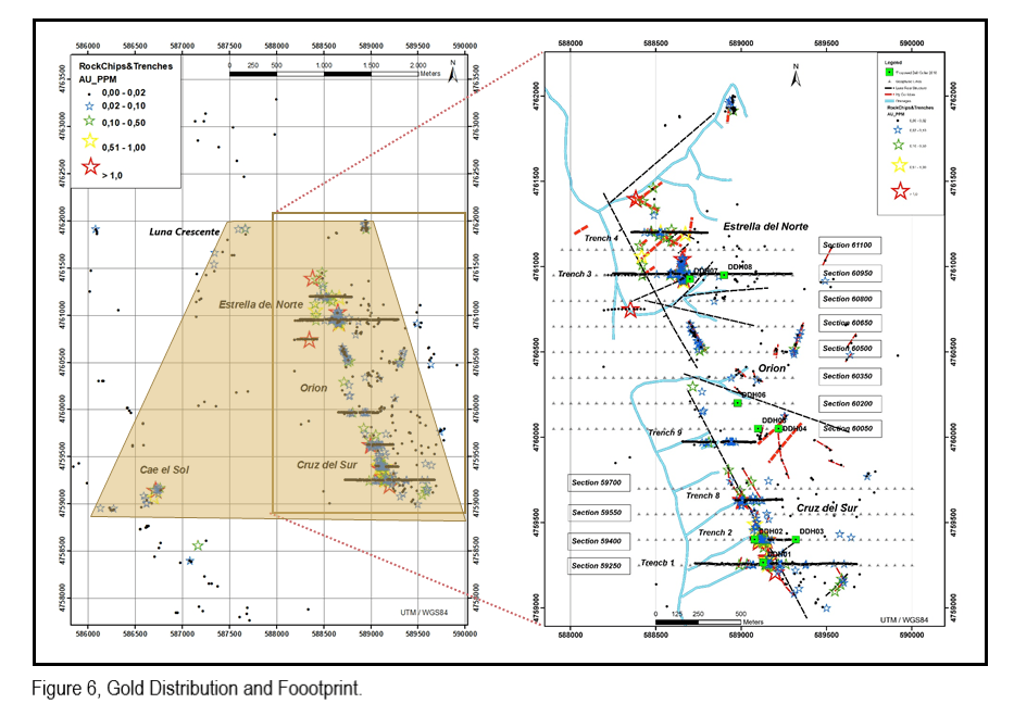
Mineralization is open along the Via Lactea Fault and at depth and also to the N-NW as well as to the S-SE. There is also potential for disseminated mineralization to the West of the Via lacteal fault across a largely covered surface area of 8 square Km (Figure 6) between the Via Lactea Fault and the Au and Sb bearing Cae El Sol and Luna Crescente Zones.
Proposed work
- Trenching - 4,000 meter program to identify targets to the West of the Via Lactea Fault.
- Diamond Drilling - 2,000 meters in Cruz del Sur Zone to assess mineralization on the Via Lactea Fault and at depth.
- Diamond Drilling – 1,000 meters in Estrella del Norte Zone to assess stockwork related Au and Ag mineralization.