
+1 (905)-301-9983
La Rosita
Commodity
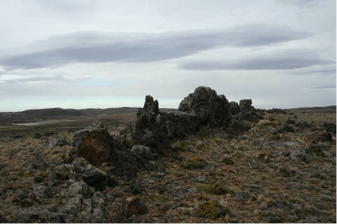
Gold in sinters
Partner
Available for Joint Venture
Location
The La Rosita M.D. is in the south-western corner of the Deseado Massif, 11km east of Gobernador Gregores (Figure 1).
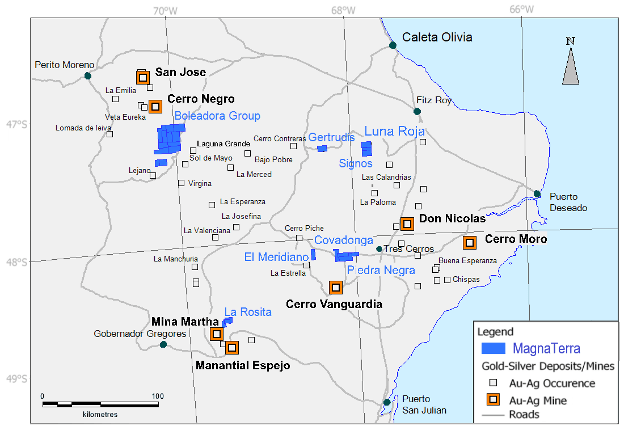
Figure 1, Deseado Massif, Magnaterra Minerals Property Map.
Project Operator
Magna Terra Minerals has 100% control, through a leasing agreement with a private individual.
Property Information
The La Rosita M.D. constitutes a 2,900 Hectare land package neighbouring the now closed Mina Martha and Manantial Espejo silver mines.
Geology
Geological mapping and sampling was carried out in 2009 by a previous operator and was accompanied by a geophysical IP and ground magnetic campaign. In September of 2010, 11 diamond holes were drilled, the most significant being DDHLR04 which included an intercept of 3 meters with 0.761 ppm Au and 926 ppm Cu at a depth of 83 metres.
La Rosita occupies a basin measuring around 4 by 4 km which is formed in andesitic and dacitic volcanics and is occupied by highly deformed cherts, limestones and siltstones which are locally altered and mineralized. The formation of this basin is the result of extension and wrenching related to major regional and district scale structures which strike NNE, N-S, NNW, NW, and WNW (Figure 2).
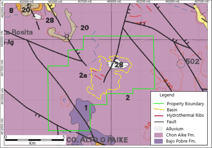
Figure 2, Regional geological map at 1:250,000 (4969-1 Gobernador Gregores) illustrating geological setting of La Rosita.
The formation of the basin provided a site of high potential for geothermal and hydrothermal fluid flow as well as the topography for sedimentation which would ultimately cover the favourable stratigraphy and much of the evidence of hydrothermal activity (Figure 3). The presence of mineralization in sinters accompanied by associated soft sediment deformation, implies an environment in which sedimentation was accompanied by geothermal activity in the Jurassic period and that hydrothermal fluids, associated with structures in the underlying volcanics, had to pass through this column of unfavourable stratigraphy before brecciating and mineralizing sinters at the surface.
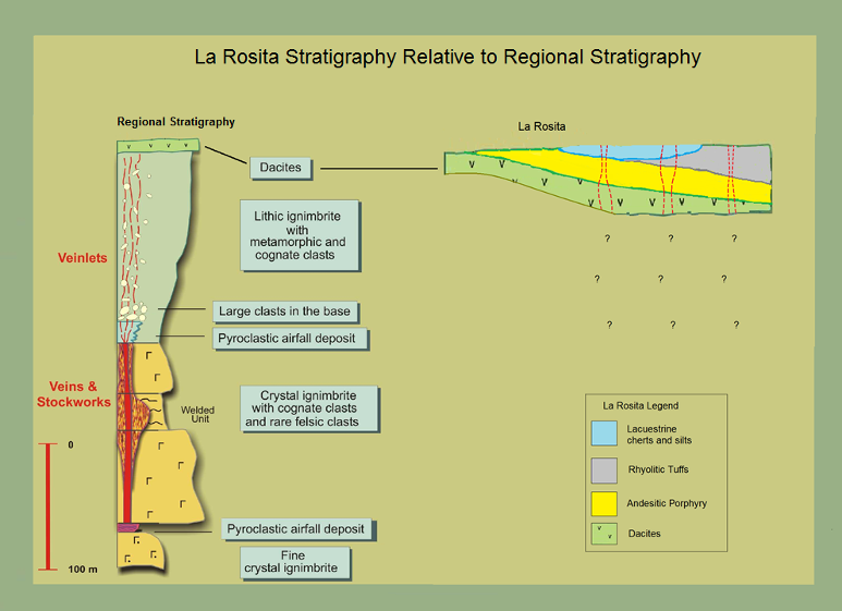
Figure 3, Regional stratigraphy illustrates vein forming units observed at Mina Martha and Manantial Espejo relative to the higher stratigraphy observed at La Rosita.
Drilling on the project, during 2010, produced multiple low-grade Au intercepts (See Figure 4). Of the 12 holes drilled, 5 hit one to several discrete intervals of at least 50 ppb Au and 2 holes intersected “significant mineralization”, here considered to be the equivalent of 2 to 3 meters (not true thickness) of at least 700 ppb.
| Hole | From | To | Length | Au ppb |
|---|---|---|---|---|
| DDHLR04 | 83 | 86 | 3 | 761 |
| DDHLR05 | 89 | 92 | 3 | 68 |
| DDHLR09 | 76 | 78.7 | 2.7 | 72 |
| DDHLR11 | 26 | 28.15 | 2.15 | 169 |
| DDHLR10 | 34.7 | 37 | 2.3 | 62 |
| 37 | 39 | 2 | 715 | |
| DDHLR10 | 41 | 44 | 3 | 117 |
| 35 | 38 | 3 | 56 |
Figure 4, Table of Au drill intercepts.
The company has has used magnetic, gradient array and IP section data to re-evaluate the property in terms of known regional structure and stratigraphy.
Three magnetic environments or domains are described: (Figure 5):
Domain I: zones of high magnetism which have a generally NW to SE orientation. These are apparently structurally controlled and may be related to fault bounded blocks of Andesite or perhaps basement blocks. These magnetic highs are generally unmineralized with the exceptions being sinter formation along the structurally controlled flanks of the blocks.
Dominion II: magnetic lows, which are generally sub-circular to elongate zones. These zones occur in between the magnetic highs of dominion I and exhibit a general NW to SE orientation. These zones may be related to changes in lithology, for example felsic volcanics infilling half grabens between blocks of andesite, or they could be related to destruction of magnetite in the andesite which may be occurring as hydrothermal fluids flow along fault boundaries, or more likely a combination of both.
Dominion III: zones of generally moderate magnetism, cut by magnetic highs and with strong variations in magnetic gradient. This domain occurs in the center of the study area and exhibits a NE-SW orientation. These zones may be related to sub-volcanic bodies such as rhyolitic dykes. We note however that the domain III area occurs in the center of the basin where N-NE and NW structures intersect, making it an area of potential fluid flow and mineralization.
The gradient resistivity data (Figure 6) are combined with the Magnetic domain data, showing that most of the surface mineralization is associated with the more resistive areas and specifically with W-NW and locally NE striking structures. The largest and strongest resistive zone is orientated W-NW along a dilatational zone.
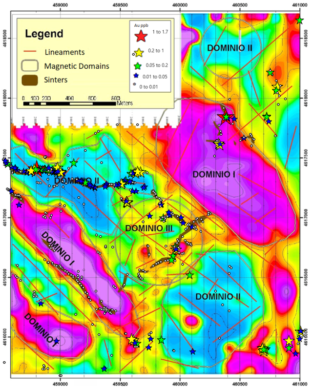
Figure 5: Reduced to the Pole Ground Magnetics with inferred structures, sinter outcrops and Au mineralization.
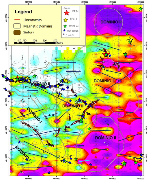
Figure 6: IP Resistivity with Magnetic domain overlay, inferred structures, sinter outcrops and Au mineralization.
We conclude that whilst the structurally controlled basin provided multiple zones of potential fluid flow and mineralization, the 2010 drilling campaign targeted Au in outcropping sinters and for the most part these holes were too shallow, collaring in and ending in the andesite porphyry. We are now considering structural targets in resistive and mildly chargeable anomalies which represent dacitic and ignimbritic stratigraphy beneath the andesite.
